
Is your field team equipped with mobile GIS? If not, your company could be missing out on the opportunity to improve decision-making, safety, and efficiency.
To get you up to speed, here’s how Esri explains mobile GIS:
“Mobile geographic information system (GIS) technology extends GIS beyond the office and allows organizations to make accurate, real-time business decisions and collaborate in both field and office environments. Mobile GIS will enable your organization to decrease task redundancy and keep data more current.”
What does this mean? If you’re a utility or manage pipes or roads and aren’t taking advantage of GIS data, your field service processes simply aren’t running as smoothly or efficiently as they could be.

The Benefits of Mobile GIS
Mobile GIS offers numerous advantages, so we’ve laid out the 4 key benefits that will make a drastic difference in the way your field team operates.
Take a look at our guide to learn all about the abilities mobile GIS provides your team, why these benefits are so helpful for field technicians, and how to use mobile GIS effectively.
1. Locate Correct Assets Quickly
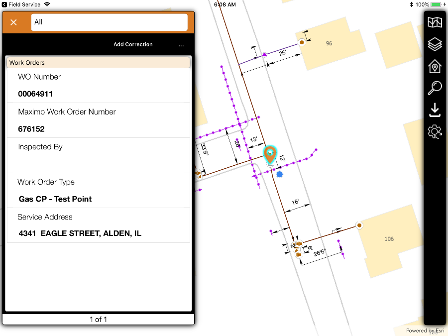
The first major benefit mobile GIS provides is its ability to easily allow users to find the right asset and find it faster. Field teams need a solution that’s easy to learn and easy to use. Locana’s Lemur technology provides workers the data they need when they need it.
Though Google Maps can provide a pin of the asset’s general location, it’s typically not specific enough to find the exact spot. Notice below how Lemur shows the specific asset to be worked on, how precisely the asset is displayed, as well as the technician’s location.
All of this information in one place significantly helps guide the field technician to the correct asset:
2. Understand Asset Connectivity and Interdependency
Mobile GIS helps organizations with risk management by allowing field teams to not only view the asset they’re assigned to inspect, repair, or replace but also understand what’s connected to it and around it.
What does this mean? Simply put, mobile GIS affords safety by helping field technicians make sure they aren’t cutting off power to a hospital or school, for example.

3. View Detailed Asset Characteristics
When you send a field technician to an assignment, it’s important that they have more information than simply where the asset is located—you also want them to have all of the engineering information along with context that the GIS provides.
With this technology, a field technician is able to know precise details like the diameter of the pipe they’re working on or what type of valve they’ll encounter.

This data allows them to view and understand the characteristics of the asset they’re working on plus other relevant assets that could be impacted by what they’re doing. This benefit allows field teams to make optimal decisions.
4. Record Work and Defect Locations
The three benefits we’ve already gone over clearly provide advantages to users by getting information to the field. However, the final benefit of mobile GIS is a total game-changer—the ability to create and record spatial data. Creating and recording spatial data is essential to helping the quality of data collection, backoffice GIS, and data processes.

Take, for instance, a field technician that’s been assigned to clean out a storm drain. If they discovered it was actually 30 feet further down the street than where the GIS showed it was, they could instantly update the location of the drain and send the data to the backoffice.
They would also be able to sketch on top of basemaps and vector data while on site. All of these capabilities can significantly improve data quality allowing it to be more accurate over time.
Summary of 4 Ways Mobile GIS is Useful for Field Teams
In summary, here’s how mobile GIS can make a major impact on your organization:
- Locate Correct Assets Quickly: Field teams can find the correct asset and find it faster than ever before.
- Understand Asset Connectivity and Interdependency: Mobile GIS allows the ability for users to view at the asset they’re assigned to inspect, repair or replace as well as understand what’s connected to it and around it.
- View Detailed Asset Characteristics: Field technicians are able to have all of the engineering information as well as context that the GIS provides.
- Record Work and Defect Locations: Mobile GIS enables the user to create and record spatial data, which greatly improves data quality, backoffice GIS, and data processes.

Now that you’re aware of the immense benefits mobile GIS can provide, you may be wondering what your next steps are.
The Lemur Platform recognizes that field technicians can be experts in everything from pipes to wires to pavement, but they typically aren’t GIS experts. That’s why it’s uniquely designed to provide a reliable, zero-training simple, offline-capable, intuitive mobile GIS platform. Not only that, but it’s easy to integrate Lemur with EAM and field service apps.
With Lemur, you can deliver GIS and work information in the same app, on the same map, and launch workflows from a map-based interface. This improves the accuracy and efficiency of fieldwork processes, as well as regulatory compliance and reporting.
***
Contact us today about integrating Lemur with your GIS or EAM field service apps.


