Locana helps integrate systems with Esri ArcGIS Utility Network, ensures successful data migration, and optimizes results
Customer
With a mantra of “We Do Things Right,” Brookings Municipal Utilities (BMU) commits to running its business with the highest standard of integrity and providing exceptional customer service. Based in the City of Brookings, South Dakota, the company supplies power to approximately 12,000 customers and manages water and wastewater utility services, internet, and telecommunications.
While the company had a successful track record using AutoCAD to manage electric utility operations, its leadership recognized the need to modernize operations. Decades of department-level systems resulted in isolated islands of data. The disparate databases met user objectives, but they resulted in multiple pockets of redundancy that consumed precious resources to update and maintain. As a result, BMU opted to replace its legacy mapping with an enterprise GIS that would integrate data, leverage powerful analysis capabilities, and provide a foundation for the future.
Working closely with Locana, BMU successfully launched a modern solution consisting of the ArcGIS System, including the ArcGIS Utility Network (UN), Esri’s next generation of network management for modeling, analyzing, and visualizing networks. The solution effectively removes silos to create timely, accurate, and complete information used for improved decision-making.
We wanted greater accessibility and transparency to our data. GIS gives us a single viewer to open data housed in different databases. By doing this, we improve our processes and make it easier and more efficient for engineers to manage the maps and data.
RUSS HALGERSON
ELECTRIC DEPARTMENT MANAGER
Challenge
BMU began its mapping journey in the world of paper, then CAD. They used the drafting and design software for more than 35 years to address department-level mapping requests and supply paper maps to field workers. The company also maintained a multitude of databases, from Microsoft Access to Excel, managing different aspects of network operations, from underground assets to field inspection forms.
A lack of consolidation created a duplication of work, wasted time, and the potential of data errors. In addition, the company needed a single source of truth—a system of record that provided a view of the network and related attribute data.
Finding the way to modern GIS
As new leadership entered BMU’s organization, the awareness of GIS as an integration platform increased. The engineering department, with a focus on the water/wastewater division, first entered the foray of GIS with an Esri enterprise software implementation. After careful consideration, BMU collectively decided to move its electric division to an Esri-based system that included UN to take advantage of the data integrity and tracing capabilities. They also wanted to support the field using of Esri ArcGIS Portal and Survey123.
BMU selects Locana
BMU selected Locana to partner on implementing Esri software, including the UN, for its electric utilities. Initially, BMU planned to execute much of the project with Locana in a support role. However, after an initial collaborative needs assessment, which included the Locana Collaboration Spectrum evaluation, BMU ultimately asked Locana to shift to the lead consulting-lead model for implementation. In addition, because of its extensive experience with UN implementations, Locana developed a detailed GIS roadmap and strategy to streamline the implementation.
And a key factor identified involved data migration. The more BMU met with Locana, the more the company realized it needed Locana’s data migration knowledge and tools for transitioning to the Esri UN and getting its disparate, legacy data into the standard Esri format.
Challenges
- Isolated data and systems
- Lack of integrated view into network
- Manual map processes
- Duplicate data and potential for error
- Limited tracking and modeling capabilities
Solution
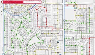
The company implemented ArcGIS UN and ArcGIS Pro, Esri’s professional desktop application for editing, visualizing, and analyzing spatial data, as part of its overall solution. They also upgraded their ArcGIS Enterprise instance to take advantage of the new UN licensing model from Esri. UN functionality helps turn the company’s previously map-centric 2D model into a high fidelity, network-centric 3D model that includes greater data detail and analytic capabilities.
A key contributor to the solution involved Locana’s Advanced Rapid Migration Engine (CARMEN). Locana leveraged CARMEN to migrate the electric data from the source systems and implemented containers and associations. This resulted in a fast, efficient data migration that might otherwise require significant time, resources, and investment by BMU.
The new ArcGIS-based solution also uses feature templates for mapping switch cabinets, which reduces the drawing time for new features and allows for rapid remediation of existing data. Each feature template is based on the inventory of actual switch gear models used by BMU. The modern system georeferences electric network and related tabular information. Staff can take advantage of location analytics to perform queries and visualize results.
“We gave Locana a goal to go live in April of 2021, which was a six-month time frame from the start date,” said Russ Halgerson, Electric Department Manager, BMU. “They did the bulk of the work, communicating with us regularly, including weekly meetings. It was a successful project that met the goals we set out.”
We’ve seen a significant improvement for a relatively small investment. The ROI will continue to grow over time as we do more and include additional integrations.
RUSS HALGERSON
ELECTRIC DEPARTMENT MANAGER
Results
Leveraging ArcGIS, BMU transitioned from departmental GIS to a spatially-enabled enterprise, facilitating simple, easy access to comprehensive maps and related information across departments. Today BMU deploys an enterprise GIS system that replaces ad-hoc legacy maps with a network model that more closely aligns with their real-world system. As a result, they have a secure, modern technology to scale for the future, enabling smooth integrations with new systems as they are implemented.
The geospatial tools allow more employees to carry out their job effectively using location intelligence. Moreover, BMU now uses a traceable network model with high data integrity to perform business functions with greater effectiveness.
Previously, using CAD for mapping and managing the network proved problematic because of the inherent limitations. ArcGIS provides exceptional tracing capabilities. It allows users to trace models that go up or down the system, previously unavailable functionality in CAD. For instance, today, if an outage occurs at BMU, users can select the downline customers affected by the outage. As a result, they improve their outage response and reporting, turning what was previously a lengthy notification procedure into a much quicker process. In addition, they improved planned outages, leveraging a faster, more efficient method to identify and contact customers.
ArcGIS provides numerous other benefits as well. Engineers can quickly push out maps using a single solution, whether a customized map or mapped data displayed for different dashboards in different departments. Operational tools help departments with day-to-day activities.
For example, the water department has a near real-time display of hydrant flushing activity updated by the GIS and includes notes and feedback about where crews are in the program. Likewise, the electric department uses a dashboard for its inspection of switch cabinets that takes place annually. It shows what’s inspected and what remains and contains notes of maintenance items and images for easy access.
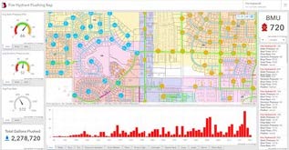
GIS-based dashboards enable improved decision-making using location intelligence.
“Locana outlined what to do and how to do it. They partnered with us to make sure we did our implementation right. Now we have a lot of Esri tools available to use,” says Halgerson.
Benefits
- Integrated data and consolidated systems
- More timely, accurate, and complete data
- Modern mapping and geospatial capabilities
- Advanced network modeling and tracing
- Improved geospatial dashboards and reporting
Future
The future looks bright for BMU. With its modern GIS in place, the organization will consider implementing containerization for transformers and substations next into its UN. As the model evolves and develops, BMU will also look to incorporate supervisory control and data acquisition (SCADA), advanced metering infrastructure (AMI), and all third-party systems to take full advantage of GIS functionality within other operational systems. They will also potentially deploy a mobile workforce and work order management system with GIS functionality to enhance data collection.
We needed help from Locana to keep the project moving, keep us on task, and do it correctly. We had one chance to make the jump from AutoCAD to GIS and the Utility Network, and we wanted to make sure we did it right, and we didn’t have to go back and fix things.
RUSS HALGERSON
ELECTRIC DEPARTMENT MANAGER
Download the full case study pdf here.