
Geospatial solutions make sense of vast volumes of data for greater clarity and decision making.
The climate change consensus
From extreme weather events to declining air quality, rising sea levels to diminishing biodiversity, the environmental impacts of climate change affect everyone. And the majority of climate scientists – a whopping 97 percent – agree that human activity contributes significantly to global warming and climate change. In addition to the scientific community, more business and government agencies are working to create sustainable solutions.
As more research becomes available, the challenge for everyone involved is making sense out of the vast reams of data to make the best decisions possible, whether it consists of a government setting emission standards, an agri-business looking to adapt its supply chain, or a utility building clean energy infrastructure. Finding the correct data, organizing it, analyzing it, and understanding it requires the right tools.
That’s where geospatial technology—and the right expertise—can make a difference. Location-based technologies hold the promise of extracting value from data created by today’s scientific community. It provides the scaling and integration necessary for business and society alike to holistically turn data into insights and actionable items that can be shared with all levels of government, the private sector, and communities.
The climate change dilemma
Today, more organizations understand that addressing climate change can position them and their constituents for greater prosperity. This includes private businesses. From tech giants like Apple and Microsoft to consumer brands like Nike, Johnson & Johnson, and Hasbro, more companies today invest money and resources in redesigning supply chains, optimizing distribution channels and logistics, and serving customer needs while preserving ecosystems. They understand that good sustainability practices mean good business—in the U.S. alone, decisive climate action could deliver $3 trillion to the economy by 2070.
But building climate-smart strategies is no easy task. CEOs, policymakers, researchers, donors, and the public all need better ways to comprehend complex research made available from organizations such as NASA, NOAA, the EU, and the United Nations Intergovernmental Panel on Climate Change (IPCC).
Geospatial technology and solutions deliver the perfect solution to this data dilemma. Mapping technology and location intelligence can provide an intuitive method to perform climate risk analytics, modeling, and reporting that people understand. Companies and communities of any size can use detailed data visualization techniques to answer a myriad of questions including:
- How do I best mitigate and respond to climate challenges?
- Where do I invest? How do I determine resource allocation?
- How do I track climate change goals and monitor progress?
- How do I influence policy? How do I advocate for behavioral change?
- How do I communicate new regulations to the public?
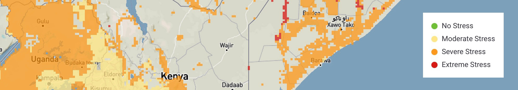
Geospatial solutions, through the power of location, provide an integration platform. Geospatial technology connects to existing systems within your organization, as well as both public and private systems dedicated to combating climate change and supplying climate data. This integration is key to revealing patterns, identifying “hot spots,” and giving context for assessing the specifics for climate adaptation.
For instance, more and more climate data are available using open-source solutions. This facilitates data sharing among nations worldwide. For countries with fewer resources, accessing open data generated by scientific communities and international organizations fosters greater collaboration and exchange.
Open data sets, models, and analytics can be easily consumed and shared using open-source technologies such as QGIS and Python, as well as enterprise GIS software from companies like Esri. Both open source and proprietary software facilitate development of solutions built on secure, flexible, and repeatable frameworks for use at lower cost and requiring fewer resources.
This means that more people today can quickly scale their mapping to meet their specific needs. Companies can look at their locations, customers, business partners, communities, supply chains, and more. Local and national government agencies can set policy that has the most significant impact on their constituents. International communities can take a global view of climate data. And in all cases, they can drill down or scale up as needed.
Geospatial solutions for every need
Geospatial solutions for climate change deliver mapping and location analysis to support decision-making that drives economic growth, protects lives and property, and maintains ecosystem vitality. You can display and interact with relevant data and analytic models using maps, which can be easily shared and embedded in apps. Solutions can be customized for any industry, business, or use case imaginable, so you can better understand climate impacts on populations, infrastructure, and ecosystems and deliver alternative approaches.
Government: Government officials can make informed decisions around regulation and policy for everything from energy and emissions standards to incentivize zoning and protect public lands. They can connect jurisdictional and socioeconomic data with scientific data and analyze how best to support their constituents. They can understand current trends, project future outcomes, and set forth data-driven programs that promote adaptation and sustainability.
Commercial: Businesses can analyze their supply chains to determine better business practices and lower energy and resource consumption. They can perform environmentally sound site selection to build new facilities that mitigate ecological impact. They can optimize their fleet operations to reduce mileage, fuel usage, and carbon emissions and ensure compliance and reporting.
Utilities: Providers identify new clean energy sources, including wind, solar, and water, using maps overlaying services areas, customers, existing infrastructure, and available land. They can perform spatial queries and analyses to identify services, products, and technologies that can grow their business. For example, they can identify optimal locations for electric charging stations for customers.
Social benefit: Nonprofits and NGOs leverage geospatial platforms to develop mitigation strategies to protect resources. Maps can help determine where and when to fund projects, as well as advocate for change. Location intelligence can help understand everything from climate impacts on the agricultural supply chain to knowing what wetlands to prioritize and protect from sea-level rise.
Agriculture: Growers and producers can use spatial data to project climate change’s impact on agricultural variables. Maps help develop and communicate practices to farmers, ranchers, and landowners using science-based approaches to reduce carbon emissions and increase land sustainability. They can improve water usage, seed selection, and pesticide controls to maximize crop yields without harming the environment.
What’s exciting is these are just a few examples of how geospatial can help across industries for climate change. Insurance, manufacturing, construction, health, transportation, and others can benefit from building purpose-built applications to enterprise systems and simple digital experiences designed.
Geospatial and climate change expertise combined
Locana is uniquely qualified to help combat climate change using location-based solutions. We sit at the intersection of technology, design, and climate change domain expertise. Our technology and subject matter experts understand open source and proprietary—how those worlds work together, and when and how to leverage both systems.
We can help you determine how to best make sense out of massive amounts of data available today, combine it with your organization’s data, then develop the right customer-driven tools so you can filter down on what you need to make a decision. And we can help you create maps that visually tell a story to increase influence and advocacy. We’re practiced in designing systems so that data of all types and from multiple sources can be updated as it comes in, shortening cycles to make it near real-time.
Our staff at all levels have worked with global nonprofits, NGOs, private businesses, and community-based organizations that range from international entities to individual advocacy groups. We are committed to our client’s success and work diligently to meet their vision, mission, and objectives, particularly in the climate field here we believe we can together make a difference in the world.


