
Locana’s Open Data & Development team hosted an online mapathon during Geography Awareness Week to contribute to OpenStreetMap. Unlike traditional mapathons that typically digitize new features, our team tested a new approach, a different user interface, and a focus on correcting map errors.
Mapathons 101
Traditionally, mapathons are organized to bring communities together to map environments important to their locality. Today, new tools and technology have expanded the scope and lowered barriers for participation — making it easier for mappers to contribute various themes and features. Mapping can refer to either tracing something using aerial photos (like a building), or correcting the digitization of something that’s malformed and/or against mapping standards (improperly mapped roundabout).
OpenStreetMap (OSM) is a collaborative project that aims to create a free, editable, open map of the world. It provides an excellent interface for communities around the globe to contribute their local knowledge and map their own communities. Hosting an OSM mapathon provides immediate feedback and support to these communities. To contribute our efforts to Geography Awareness week, Locana created a virtual OSM mapathon. In the following sections, we’ll walk through the conceptual arrangement and planning of a mapathon, Locana’s experiment, and observations from our inaugural virtual mapathon.
Getting Started
Hosting a successful mapathon is similar to hosting a focus group; a clear purpose and focused theme, effective marketing and communication, engagement of participants with similar interests, and inclusive event space are all essential ingredients. In addition, having facilitator(s) that are familiar with the OSM data model and mapping best practices is key. Here are some tips to assist you in your mapathon planning:
- The purpose should be simple. What do you want to accomplish with your participants? Examples include: digitizing parks, squaring and closing buildings, or realigning roads using aerial photos or satellite imagery.
- The complexity of your theme should match the participants’ knowledge and skills. If you’re hosting the event for a large group, consider providing training materials beforehand to mitigate potential barriers to participation.
- If hosting a mapathon in person, it’s important to select an open but dedicated space. The participants should feel relaxed and free to ask questions and engage with other participants.
- Target the duration of the event to be between one and four hours. If the duration is longer than one hour, consider multiple sessions to provide more participant interaction.
- The facilitator plays a pivotal role. Facilitators should be able to answer all types of questions participants may have, as well as control the agenda and schedule. This is particularly important if there is a training session before the mapathon or the length is over two hours. Specifically, the facilitator should know the contents of what will be mapped in detail, be able to provide directions on different edits, and most importantly, transfer their knowledge to the participants with ease.
Experimental Mapathon: New approach, platform, and mapping content
To celebrate Geography Awareness week at Locana, we organized a company-wide mapathon with a twist: 100% virtual. The planning and preparations were slightly different than conventional mapathon. Here’s how we set it up:
- Uploaded MapRoulette Challenges for 24 US and 2 UK cities based on staff locale.
- Created seven training videos to educate participants on how to edit different map errors.
- Posted MapRoulette Challenges including both geometry and tagging errors.
- Broadcasted the event via email and Slack.
- Kept the mapathon open for a few months to allow users to find time to participate and collected data on users’ interaction and activities.
- Hosted an in-person mapathon as a control group by using the same MapRoulette challenges.
Lessons Learned
Our virtual mapathon experiment was a hit from the beginning. In the first two months, we collected more than 800 edits from 27 different contributors (25% of participants were new mappers!).
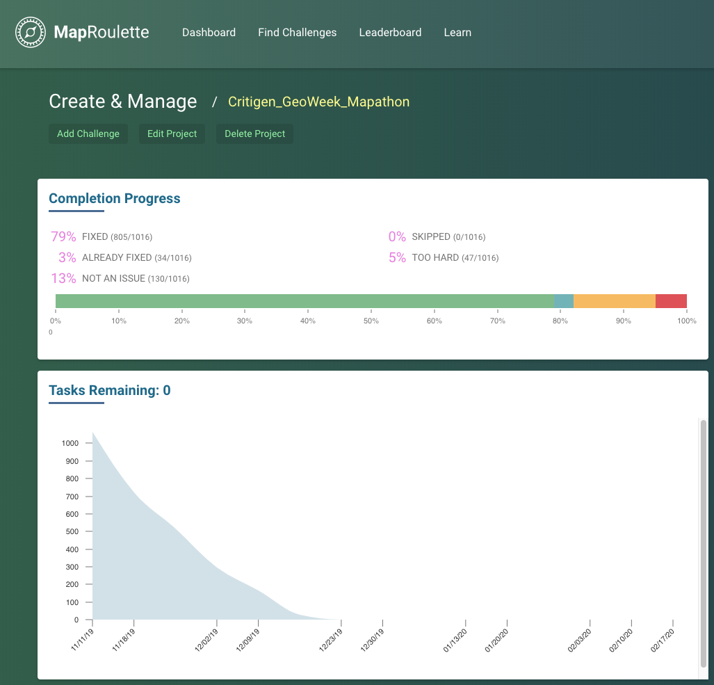
Completion Stats for Our Mapathon
Three main takeaways emerged from our experiment:
- Keep it simple. Most edits were simple geometry fixes because it required the least amount of research. For attribution-based map errors, the challenge difficulty was heavily dependent on resource availability. For example, without great street-side imagery, correcting and validating speed limit tags is virtually impossible. Mapathon organizers should evaluate the feasibility of edits when creating tasks that rely on different resources. In addition, providing fix scenarios could help facilitate edits. For instance, when flagging an address point that’s missing a road name, providing nearby street names for mappers to select from may be an easier editing task than having them research surrounding roads to find the correct name. Keeping tasks simple and small allows mappers to get into a rhythm and really crank through some fixes!
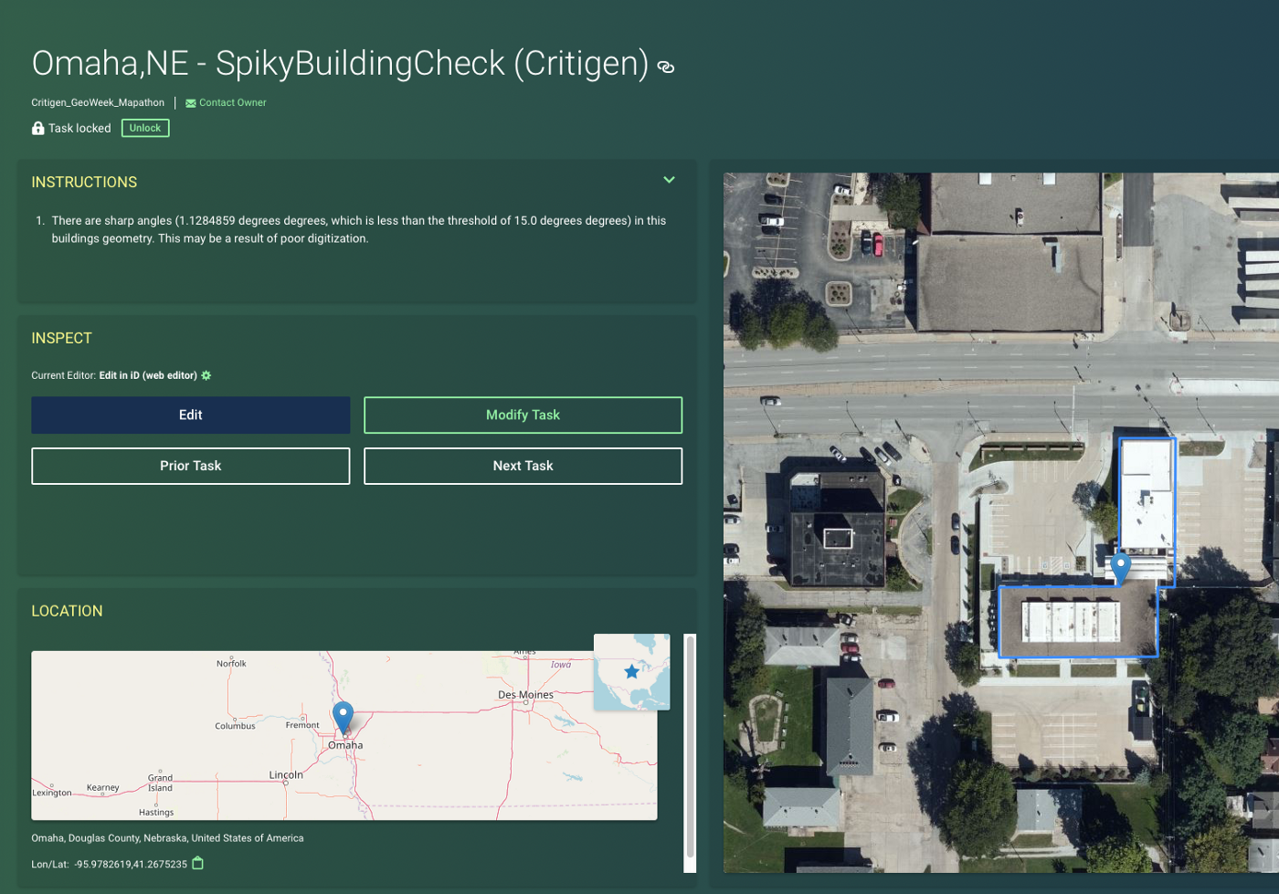
Example editing task for the Spiky Building Check
- New theme: correcting map errors. The locality is always important in conventional mapathons so that participants can feel engaged and contribute their local knowledge to the map. Our experiment populated 26 cities based on where Locana staff are located. However, we observed that participants preferred working on editing tasks they were interested in (e.g. feature types or attributes), rather than focusing on making edits in specific cities. We noted that locality was a minor factor to consider when developing tasks, particularly when correcting map errors was the event’s theme. Over time, as OpenStreetMap is becoming “complete”, we’ll all need to focus on perfecting map quality and finding some smaller scale changes and fixes.
- Communication is critical. Our control group had more conversations and exchanged ideas on how to fix difficult map errors, enabling our group to fix tasks that were not as straightforward as others. While participants in the control group work with OSM data every day, a knowledge gap was present when it came to editing features. Scheduling remote office hours and/or working with key, local stakeholders may mitigate communication and knowledge gaps that exist.
It’s Your Turn!
We enjoyed hosting a virtual mapathon, here are some ideas to make the most of your experience:
- Host simple editing tasks and make sure all resources (aerial and/or street-view) are available (by reviewing sample tasks).
- Since cities/regions are not as critical as they would be in a conventional mapathon, it’s a good idea to generate tasks for an area that require many fixes (a critical density of issues).
- Have dedicated remote “virtual office hours” for volunteer Q & A and discussions. Send out reminder emails to help promote and engage more people.
- Reward participants by sharing their efforts and achievement with the community. A leadership board for personal achievement is used in most platforms nowadays, but we think community recognition may be the next stage of rewards.
- If planning to host a virtual mapathon routinely, consider combining with some dashboard metrics to monitor and analyze the project process over time.
Mapping new features can be fun, but correcting map errors makes OSM better. By sharing our experience, we hope to inspire more mapathons to focus on improving OSM data quality in the future!
Youtube Training Videos
- Atlas Checks and Map Errors Introduction
- MapRoulette Introduction
- OSM Editing Introduction
- Editing Demo— Address Point Match Check
- Editing Demo— Building Road Intersection Check
- Editing Demo— Spiky Building Check
- Editing Demo — Unusual Layer Tag Check


