OSIsoft PI System and Esri ArcGIS Integration by Locana
 Organizations such as utilities, local governments, Federal agencies, and the U.S. military have invested heavily in devices and systems that allow them to collect and store real-time, sensor-provided data. These organizations have also invested heavily in enterprise spatial information management systems, or GIS. Integrating these disparate systems:
- Enables map visualization of operations data for improved decisions
- Provides time-series performance data at locations for predictive analysis
- Delivers real-time access to location-based data for mobile workers
Add the ‘Where’ Dimension to Better Solve Your Problems
Integration of GIS with operational data can help you with the following problems (and many more):
- Does your organization depend on asset or equipment portfolios that are dispersed and cover vast areas?
- Is the dispatch of organizational staff and equipment mission-critical? Does it require up-to-date location and asset information?
- Do regulatory and compliance issues require analysis of location proximity that can impact operations and planning?
The Locana Solution
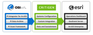
Locana helps you bridge the gap between your enterprise spatial information in GIS and your real-time operational data. Locana employs numerous integration methodologies, including the PI Integrator for Esri ArcGIS, developed jointly by Esri and OSIsoft, as well as custom integration methodologies to support specific use cases, requirements and data.
Realize the Benefits of OSIsoft/Esri Integration
Configured Solutions to Get You Up and Running
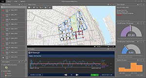
Using existing COTS framework solutions, Locana can quickly configure complex integration portals displaying real-time asset information, vehicle locations, and other data analytics to provide a complete operational view.
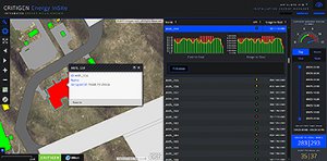
Custom Solutions to Address Your Specific Needs
Some organizations have complex business workflows that require custom solutions based on COTS products. Locana has years of experience developing effective custom solutions that support our client’s business needs, use cases, and requirements.