
Maintenance Workers Need GIS
 Fast understanding of the work to be done reduces wait times and return visits. With GIS showing not only aerial imagery, but also the actual utility network (e.g. gas lines, water service lines, electric secondaries), the crew can get key information on the job before they arrive. Just by looking at the GIS information they can see clearly where the service line connects to the main, where relevant valves are and even IOT or meter data in near real time when connected. Adding imagery shows whether things like streets, curbs, and drains are likely to affect the work.
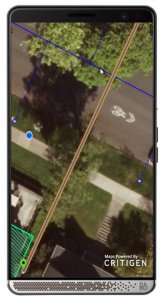
In the example at right, a team assigned to respond to a damaged gas service line sees clearly which service line is affected, and that there’s a good chance of encountering major tree roots in their work. They may call in an arborist before arriving to ensure the trees don’t slow their progress unduly. In some organizations, this work might be done first by a planner or by a crew member riding shotgun. Similarly, the crew can turn on layers to see other buried utilities and have a good idea what to be careful of.
Finding work quickly and accurately helps get the work started faster once the crew arrives. Hydrants are a common example of this need. Large commercial sites like shopping malls frequently have dozens of hydrants and stand pipes but a single address. Each has an identifier that isn’t always visibly represented on the hydrant. As crews flush and test hydrants, they have to find each hydrant and ensure that they’re reporting the pressures and any damage on the proper hydrant. GIS tools solve both challenges by providing not only the location of the hydrants and their IDs, but also placing the user’s location on the map so they see clearly which hydrant they’re standing next to. With Lemur™ and a compatible Mobile Work Management App, the crew could simply tap the hydrant and select “report” from the menu to ensure that their report was completed on the correct hydrant – no need to copy/paste or re-type IDs.
Ease of use is critical for field teams. GIS maps provide both an intuitive display of work and a simple data-rich navigation tools. The GIS becomes a visual mobile work dashboard for the crew with tappable color/icon-coded assets providing a wealth of relevant information. When work is displayed on the GIS map, the field team no longer needs to worry about what information is in GIS (typically location + engineering data) and what is in the Work Management system (typically transactional information). Lemur™ makes data from both systems navigable through a single unified map interface and eliminates paper maps or awkward transitions from map to service app and back.
Accurate, simple data collection from the mobile devices benefits both the organization and the field crew. Field crews love to be able to correct data so that over time the data in the system becomes more accurate and reliable for them. They can also do simple tap-and-record operations for things like leak readings, pole tests or corrosion point inspections, and use pre-configured sketching tools to record locations of new or ‘discovered’ assets. This all supports transparency and knowledge capture for the organization, and we’ve seen as-built processes sped up from 180 days to less than three days as a result of these tools!
To make your organization’s GIS useful to field users, it must be delivered in a way they will understand immediately, with virtually no training and connectivity to the Work Management system. Lemur™ makes it easy to integrate GIS with best-of-breed Work Management Solutions, allowing teams to navigate seamlessly between GIS and compatible field service tools
Ty van den Akker is a leader in product strategy and manages Locana’s Lemur product that delivers mobile integration between GIS and EAM field service apps.


