Development platform improves usability and adoption of coastal resilience and ecosystem services maps and data
Customer
Founded in the U.S. through grassroots action in 1951, The Nature Conservancy (TNC) has become one of the world’s most effective and wide-reaching environmental organizations. Thanks to more than a million members, TNC impacts conservation in 76 countries and territories with a mission is to conserve the lands and waters on which all life depends. It works to address biodiversity and climate change to shape a brighter future for people and our planet.
As part of its Coastal Resilience and Mapping Ocean Wealth programs, TNC established a geospatial development platform that provides internal staff and business partners solutions for addressing coastal hazards and examining ecosystem services.
“We partnered with other non-profits, academia, and private consultants to provide one of the most widely used platforms for climate adaptation solutions in the world,” explains Zach Ferdaña, Director of Conservation & Geospatial Systems at The Nature Conservancy. “It starts with understanding your audience. We worked with Locana to design technology around target audiences to help them recognize the benefits of conversation and restoration that leads to protecting people as well as nature.”
“The assessment of target audience is critical in any app development process to ensure user adoption for making conservation decisions. Once you know who you are speaking to, design and data accessibility become essential. This is the holy grail of the app development workflow.”
ZACH FERDAÑA
Director of Conservation & Geospatial Systems, The Nature Conservancy
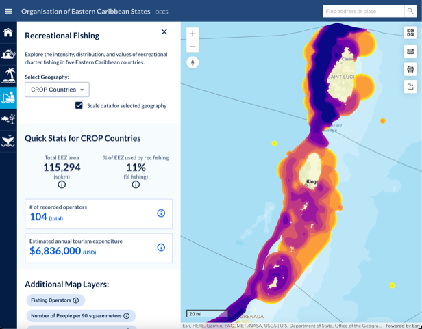
Recreational Fishing: Heat mapping makes it easy to see the impact of recreational fishing on eastern Caribbean states.
Challenge
TNC has a deep geospatial workbench, with more than 1,500 staff leveraging mapping capabilities as part of their conservation work and more than 700 professional GIS staff using Esri ArcGIS software for conservation science, planning, and action. In addition, the Director of Conservation & Geospatial Systems works across the organization on GIS and earth observation disciplines to develop cloud architecture, database management and governance solutions used to track place-based conservation strategies and objectives.
Given TNC’s large geospatial workforce, they recognized the need to build mapping applications at scale around ever-increasing project work. As a starting point, its Global Marine team sought to improve usability and adoption across their Coastal Resilience and Mapping Ocean Wealth platforms. They wanted more TNC staff and partners to use geospatial data as a decision support system without worrying about varying degrees of GIS literacy. To do this, they needed an application development workflow that ensures data and technology address user needs. The fundamental question to answer—can different stakeholder audiences understand how these platforms help make science-based decisions?
TNC also wanted to make information and tools more open and accessible to members, conservationists, and donors. They also wanted to broaden their reach for passive users, such as students, tourists, and media, to access information using Web GIS.
Locana, which supports not-for-profits, private and public organizations to implement effective technology solutions, approached TNC to see if there was an opportunity for collaboration. As a result, they formed a partnership based on several factors, including compatibility and passion around the mission and geospatial work at TNC.
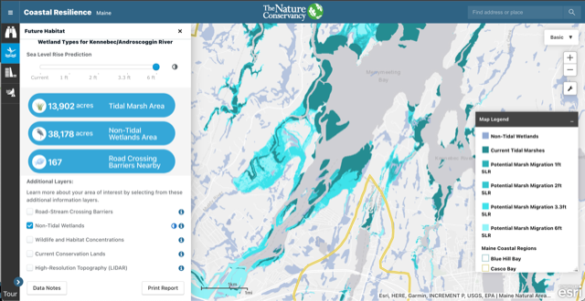
Wetland types: Selecting map layers provides a data overlay to understand sea level rise and coastal resilience challenges.
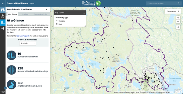
Aquatic Barrier Prioritization: Users can perform a deeper dive into aquatic barrier prioritization data using intuitive tools.

Challenges
- Extensive time and resource requirements
- Redundant data and technology
- Lack of application standards
- Poor digital mapping experiences
- Ad hoc app development
- Better customer experiences
Solution
Locana worked closely with TNC to enhance specific apps on the Coastal Resilience and Mapping Ocean Wealth platform. Both organizations wanted to make it easier to build user-centric, intuitive applications that unlock the incredible geospatial work TNC does worldwide. Specifically, the companies collaborated to advance a web framework that modularized the application development process based on project and geography. Locana used the ArcGIS API for JavaScript to build web apps, with ArcGIS for Server Feature Services used to serve spatial data and nonspatial tables over the internet. React open source technology served as a front-end JavaScript library for developing the application UIs.
With Locana’scontributions, TNC has advanced its applications specific to geography and context that help answer questions for decision support. For example, the coastal issues in Maine are different than Florida, which are different than Texas. TNC can adapt a Web GIS application to the local geographic context based on specific project parameters. Everything is component-based, so each application can reuse several modules, giving users a similar experience across applications.
The solution is an effective starting point for application development, making it easier for TNC geospatial scientists and conservationists to leverage Web GIS for individual projects. It streamlines the release of the geographic content to end users who need ready access to information concerning coastal issues, climate adaptation, or the benefits of ecosystem services.
“They were in the early stages of developing a reusable platform to make sure that multiple projects can benefit from every dollar they spent,” explains Todd Slind, Vice President, Open Data and Development, Locana. “Using a consistent visual language as part of the user experience is a more effective way to communicate and improve advocacy for the things they care about.”
“For Coastal Resilience, we have developed an online mapping framework modulated for a specific app that supports different environmental issues, whether it’s sea-level rise, an economic evaluation of nature-based solutions, or the ecotourism value of coral reefs.”
ZACH FERDAÑA
Director of Conservation & Geospatial Systems, The Nature Conservancy
Results
The Coastal Resilience and Mapping Ocean Wealth mapping platform supports a community of practitioners worldwide who apply spatial planning innovations to addressing coastal hazard risk and adaptation issues while supporting resilience and ecosystem service benefits. In addition, it provides geospatial access to peer practitioners, as well as tools, information, and training focused on nature-based solutions.
TNC worked with Locana to increase the efficiency of its resources by targeting specific audiences and improving the usability of the platform with intuitive UX/UI design applied to specific web apps. The overall workflow improves how data and technology get used by specific users and partners and allows TNC to launch new apps faster and at lower costs. It gives project managers and application owners a more reliable expectation of resource and schedule requirements, spurring wider platform adoption.
Red Cross
An early example of this type of collaboration and user-centric approach involved the TNC working with the Red Cross in the Caribbean through TNC’s Resilient Islands program. In places like Grenada and the Dominican Republic, the platform helped users build a series of maps for marine spatial planning and restoring coastal ecosystems such as mangroves and coral reefs.
Initially, TNC and Red Cross partnered to look at strategies for bringing humanitarian and environmental work together, answering questions like, “how do we keep people safe along the coast using nature-based solutions?”
A key objective was to help the Red Cross consider coastal ecosystems in deploying resources as part of both their preparedness and disaster response strategies. If the Red Cross knew where these ecosystems provide a buffer to wave energy and storm surge, thereby reducing coastal community damage from storm events, they could better deploy limited resources to more severely affected areas. TNC wanted to contribute critical ecosystem data by identifying where nature could be conserved to provide this ecosystem service, as well as where restoration should occur to increase the protective nature of these systems.
TNC led a workshop in Grenada, using a collaboration framework facilitated by Locana, to understand their specific needs and pinpoint how nature can protect people. This included gaining a deep understanding of user needs based on what they were trying to accomplish, looking at where ecosystems exist, what natural preparedness resources those ecosystems provide today, and how to restore ecosystems in need in the future.

Benefits
- Extensive time and resource requirements
- Systematized, modular development platform
- Reusable components
- Intuitive UX and UI design
- Fast, efficient Web GIS deployment
Future
With a solid foundation in place, TNC continues to evolve the platform and build applications to communicate valuable conservation information to multiple stakeholders, from community planners to donors to the public. It serves as a starting point for the next phase of spatial asset mapping. This phase includes evaluating, mapping, and prioritizing projects based on condition over time using field and remote monitoring methods. It also includes status reports via online dashboards that help TNC track its organizational goals. In addition, the work advances the organization’s ecosystem management approach that includes humanitarian, insurance, and tourism objectives.
“Spatial action mapping puts the action in asset mapping through assigning specific management objectives across sectors,” says Ferdaña. “We need to leverage technology and ecosystem data for bigger conservation outcomes. Through the important conservation work we do, coupled in part with intuitive design and app development provided by Locana, we can get that much closer to making technology truly actionable towards our long-term sustainability goals.”
“The platform increases the reusability of resources and leverages a significant technology investment to make each app less expensive to develop, more efficient to maintain, and more consistently and coherently communicate TNC’s brand.”
TODD SLIND
Vice President, Open Data and Development, Locana