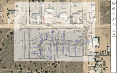
Does your organization have fast, simple, and intuitive tools that provide your field technicians with offline-accessible GIS data?
They also care about improving the safety and efficiency of the work field technicians do as well as their operations as a whole. Giving field crews access to GIS basemaps offline provides field workers the tools to make safe, smart decisions in the field.
Take a look at our guide to learn why it is crucial to equip your team with GIS mapping software that’s offline-capable and how to implement it in your organization.

Image via Locklizard
The Advantages of Offline GIS
Locate Assets Easily
The work that’s required from field technicians often puts them in offline conditions. This is due to the fact that every area has low/no bandwidth zones. Without online access to the GIS data when offline, the imprecise art of figuring out the correct asset location can be time-consuming.
Quick access to this data can be especially helpful in situations where assets are buried or not readily identified from ground level. For example, a field technician that needs to maintain or repair a sewer main needs to identify the correct segment and how to access it. GIS helps them find it quickly by allowing them to identify location and asset/serial numbers. This helps them to know which manhole to use.
Avoiding the possibility of working on the wrong asset saves time, money, and most importantly helps ensure the safety and health of the public and the overall system.
Understand Your Surroundings
The benefits of offline GIS are especially noticeable for new field technicians who may not be as familiar with a region as more experienced field technicians. It’s crucial that they have constant and reliable GIS data.
Even experienced technicians may not be familiar with new construction areas or may not have readily available landmarks to help locate assets. An offline mobile GIS app will help guide them to the correct asset in the location they’re working in.

Handle Emergencies Effectively
Offline GIS access is most essential to field technicians when it comes to emergencies. When GIS data is always available to field technicians, they’re equipped to deal with emergencies and unexpected situations without the need for internet connection or cellular service, and access is lightning fast!
Technicians called in from neighboring territories for storm recovery are dramatically more effective when they have a GIS to familiarize them with the area, much the same way new technicians benefit from an offline-capable GIS utilities viewer.
During a weather event like a tornado, a field technician may be without online connectivity for hours or even days. These times, more than any other, are when field crews need to rapidly find out exactly where the infrastructure is or where it’s supposed to be if it’s been damaged.

Improve Workflow Efficiency
Since most field technicians rely on mapping data outside of the office, it’s crucial that their projects are available on smartphones and tablets no matter the condition.
This is due to the fact that organizations need to know the location of their valves, pipes, meters, and other assets and need to know that precise information at all times. Having offline GIS makes this possible by allowing users to instantly view and analyze real-time asset information based on an asset’s spatial location and its relationship to other features no matter where they are.
Having instant access to the data you need improves the efficiency of system workflows by allowing field crews to make fast, informed decisions while they’re out in the field and reduce time consuming calls to the office for information.
Equip your Field Technicians with Offline GIS
Delivering GIS to field technicians is deceptively challenging. GIS data volumes are large. Offline caching is difficult to manage at scales above a dozen or so users or a territory larger than a typical county. Information is delivered to users who generally aren’t tech-savvy and certainly aren’t familiar with fundamental concepts of GIS.
You should consider each of these challenges when you select an app to deliver offline-capable GIS data and tools to your technicians. Hiring a consultant with extensive experience in implementing mobile, offline GIS is essential. Checking references from customers of a similar scale is the only way to be confident the app will scale to your needs.
***
Contact us today to learn how to improve the safety of your field crews and the efficiency of your workflows with Lemur.


