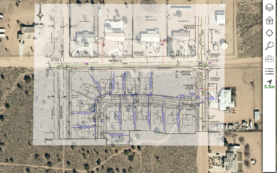
Replacement of archaic processes is the first big back office win when GIS is deployed to the field. Consider just the expense and inefficiency of distributing needed GIS data to the field, then consider how the processes would look with mobile GIS tools fully integrated with the EAM/CMMS/work management apps field crews already use. A couple of examples:
- Stop printing map books and diagrams. Preparing, printing and distributing map books can require multiple FTEs at many utilities, plus require outside printing expense, all to produce maps that are out of date before they’re printed and contain far less information about the assets than is actually available in the GIS. Mobile GIS is now more reliable than paper – It is available offline, and with a simple case it is more weather proof.
- Stop managing service cards. Historically a physical card that could be marked up, many service cards have been scanned to a document management system to avoid sending paper cards holding vital information about the service into the field. While this approach protects the corporate data and eases distribution, it still locks up location data in a document management system with its own IT challenges for distribution (especially offline). It also makes it impossible for most field tech to update information about the service location and can make it difficult for field teams to pull service cards for neighboring services when required. Providing service location information through GIS addresses all these issues.
- Reduce calls to engineering by providing the asset information often contained in the GIS to the field crew. When crews can simply tap the asset to get the full detail, they not only reduce the burden on engineering but there’s less opportunity to miscommunicate about which asset and what information is needed.
Integrate GIS data with ERP. The GIS is a system of record and contains valuable information to users in the field and back office. Third party tools like Locana Lemur™ extend the ArcGIS Platform to allow non-geospatial field users to easily consume, update and create geographic data in the field directly from their non-spatial business applications. Locana has integrated GIS data to SAP EAM, SAP ECC, SAP Work Manager, Salesforce Field Service Lightning, Innovapptive mWorkOrder and many other systems to provide seamless system integration for location and engineering data stored in the GIS. With Lemur the field can send richer, more accurate data back to the back office. This results in faster information cycles, better data, better operation of assets, and more money to the bottom line.
What additional ways can mobile GIS benefit the organization? Share your experiences in the comments please!
Ty van den Akker is a leader in product strategy and manages Locana’s Lemur product that delivers mobile integration between GIS and EAM field service apps.


